Radon Gas Map (or Radon Potential Map)
A radon gas map (also known as a ‘radon potential map’) shows the risk of having high radon gas levels in a particular area. They are usually produced from geological data that predicts the the potential of radon gas emanating from certain kinds of rocks. Radon maps may also incorporate data from various sources e.g. radon tests in an area.
These maps can be useful resources to decision makers and public health officials who can use this information to target resources, prioritize outreach.
Homeowners need to exercise caution in interpreting radon gas maps because they address a large area as an average. Green (“safe”) zones in a radon map indicate a lower risk of high radon levels. However, high radon level can be found in any home in any part of the map. This means that if your home is located in the green (“safe”) zone of a radon gas map, it does not guarantee that radon levels are low in your home. The only way to ascertain is to get your home tested.
What a Radon Gas Map Cannot Tell you
A radon gas map will not tell you how much radon is in your home. The map addresses a large area as a whole, and not individual homes. Even if your home is located in the “safe zone” of a radon map, it could still have high radon levels.
Radon Gas Map for Canada
The work to produce a gas map for Canada was initially done by the folks at Radon Environmental Management Corporation in 2011. The map was produced mainly by extrapolating geological data from the US to Canada and applying the same methods used in producing EPA radon zone maps in the US.
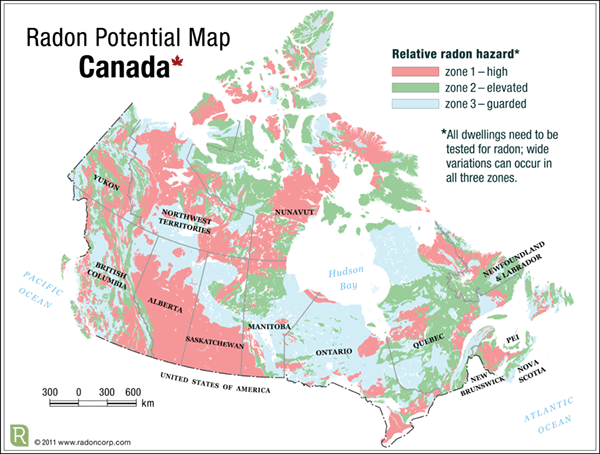
As you can see from the map, it predicts that the potential for high radon levels exists for many regions in Canada.
As mentioned before, this map relies only on geological data. Geological data can be used to estimate radon potential because we know the kinds of rocks that are likely to produce radon gas.
However, geological data tell half the story. What we care about is the indoor radon levels in our homes. Beyond the geological makeup of the soil, indoor radon levels also depend on other factors that affect how radon gets into a home (e.g. spaces for radon entry, air movement, ventilation, ice cover etc). Therefore most radon maps such as this can always be enhanced by additional data e.g. from actual radon tests.
In 2012, Health Canada published the results of its survey of radon gas levels in Canadian homes. After testing 18,000 homes all over Canada, the highlights of the study were that:
- 7% of Canadian households have high radon gas levels (more than 200Bq/m3)
- There are no ares of Canada that are ‘radon-free’ radon was found in every region.
One of the objectives of the study was to develop a map of indoor radon exposure levels across Canada. The data from that survey, combined with geological data can be used to develop a more precise map for radon gas levels. In addition it can help us understand how different factors affect indoor radon levels.
The CBC put together a neat tool based on Health Canada data that shows the radon test results across Canada on a map.
Local Radon Potential Maps
In BC, RadonAware is working with stakeholders to develop a radon potential map the the province of British Columbia. Other initiatives are ongoing to develop more localized radon potential maps that can help decision makers and the public in Canada to understand their radon risk better.
Update: 29th March 2017
University of Calgary scientists have released the results of a study that mapped radon gas across the wider Calgary area. They found that 1 in 8 homes tested for high radon levels above the recommended guideline of 200 Bq/m3.